
Export your Rust map (.map, .raw and .png)
When your terrain is ready, open the Export panel from the toolbar to write it out for RustEdit. The outputs are chips in three rows, and everything you light up writes in the same click. Crucible writes a true 16-bit heightmap, which is what RustEdit needs for smooth, detailed elevation with no banding or loss of precision.
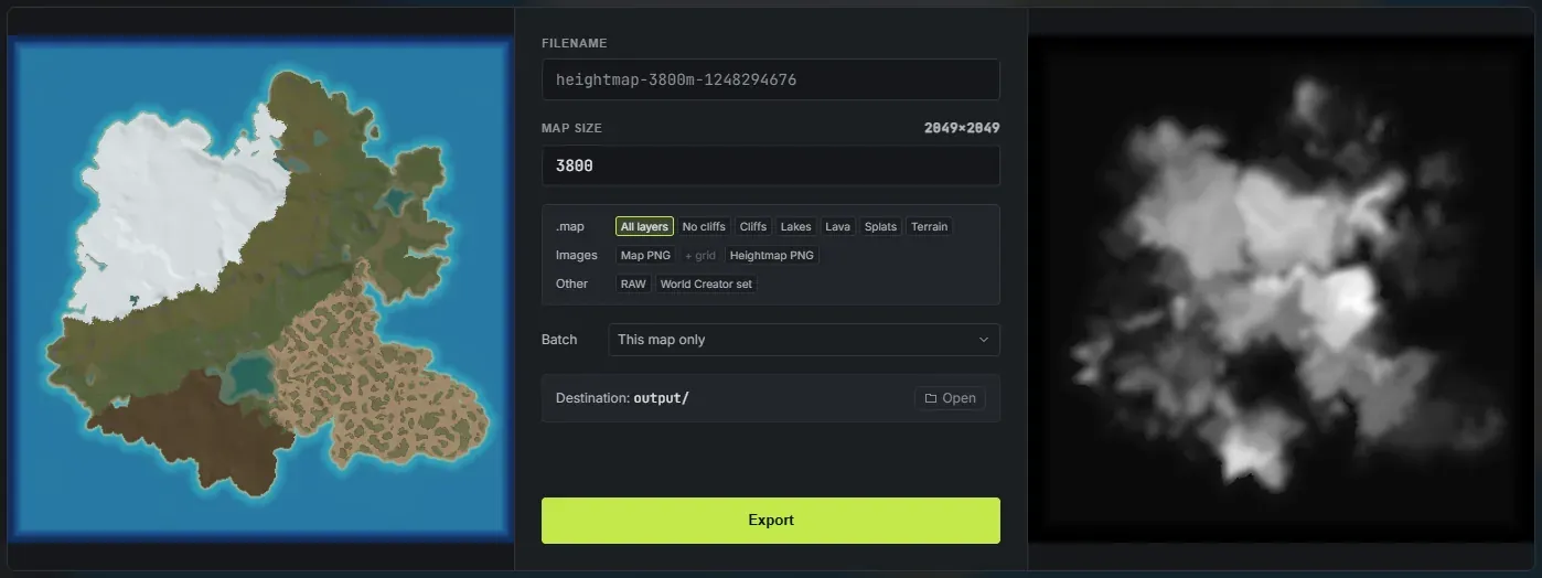
Either side of the controls are two live previews: the coloured map on the left, the 16-bit heightmap on the right, both of the map you are actually looking at.
The .map row
Section titled “The .map row”Seven chips, and you pick one. They are seven versions of the same file, all of which open straight in RustEdit, and they differ only in how much of the world comes with the terrain. Clicking the picked chip again turns the .map off, for when you only want a picture or a .raw.
- All layers (picked by default): the complete world. Your terrain, your ground textures, and everything the worldgen derived (biomes, topology, lakes and a volcano’s lava), plus Rust’s real cliff and rock models placed on the steep ground. See export a Rust .map file.
- No cliffs: everything above except the cliff and rock models. Biomes, topology, lakes and lava all ship; the rock placement is left to RustEdit or to you.
- Cliffs: the cliffs only. Every lake is handed back to the ocean and no lava is placed. A lake’s
LakeandLakesidelayers becomeOceanandOceanside, so a basin below sea level fills with sea instead of sitting empty. - Lakes: the lakes only. No cliffs and no lava.
- Lava: a volcano’s lava only. No cliffs, and every lake is handed back to the ocean. On a map with no volcano this adds nothing.
- Splats (biomes and splats only): terrain, ground textures and biomes, with no topology layers, no cliffs, no lakes and no lava. For when you want RustEdit’s own proc gen to lay the rest down.
- Terrain: bare terrain. No ground textures, no biomes, no topology. For when you want to build the world in RustEdit yourself.
The cliffs, the lakes and the lava are generated at export, so you get them whether or not Generate cliffs, Generate lakes and Generate lava are ticked in the Worldgen panel. Those three decide what you preview while you work, not what ships.
The Images and Other rows
Section titled “The Images and Other rows”These are ordinary toggles: light up as many as you want.
- Map PNG: a full-colour picture of the map with its ground textures applied, biome-tinted exactly as it will look in game. Great for showcasing a map or planning before you build.
- + grid: writes a second copy of the Map PNG with the in-game grid and its cell labels (A0, B1 and so on) drawn over it. It only does anything with Map PNG on, so it stays greyed out until then.
- Heightmap PNG: the plain 16-bit grayscale heightmap as a .png. Good for previews, sharing on Discord or socials, and archiving. It is not for importing into RustEdit.
- RAW: a standalone 16-bit .raw heightmap, the format you import on RustEdit’s own Heightmap field when you just want bare terrain. See how to make a custom Rust map.
- World Creator set: the heightmap, the splat maps and a small
.xmlconfig, which is what RustEdit’s World Creator importer takes. This route carries height and splats only, because that is all World Creator accepts. See import splats into RustEdit with World Creator.
The fastest path is the default All layers .map on its own: export it, open it in RustEdit, and the whole world is there. The other outputs cover previews, archiving and the older World Creator workflow.
Export several maps at once
Section titled “Export several maps at once”The Batch row reads This map only until you change it. Open it and tick your saved projects, and the same Export button then runs the whole list instead of the map you are looking at: each project is loaded, exported at its own map size, and written into its own folder under output. It runs on the same progress bar, so a whole wipe’s worth of maps goes out in one pass while you do something else.
Set your map size
Section titled “Set your map size”The Map Size field is the same map size as the one on the main screen: change it in either place and both stay in sync, so the .map, .raw and .png all export at the matching resolution. Type any size from 1000 to 6000 meters (default 3800). See map sizes and resolutions.
What resolution does it export?
Section titled “What resolution does it export?”Your heightmap resolution follows the map size: 513, 1025, 2049 or 4097. These match RustEdit’s heightmap resolutions exactly. See map sizes and resolutions.
Where exports go
Section titled “Where exports go”Exports save to the app’s output folder next to the program. A saved project gets its own output/<project>-export/ folder so each project’s files stay together; an unsaved workspace exports to the root output/. The Open button at the bottom of the panel reveals that folder in Explorer. The panel stays open after an export, so you can change a setting and export again, and closes on Escape or a click outside it.