
Sliders reference
Crucible Heightmap shapes terrain with sliders, grouped in the sidebar. This page covers every slider: what it does and when to reach for it, with its range and default. Double-click any slider to reset it to its default, and you can save your own defaults (see Settings).
Heights map to Rust’s world height of 0 to 1000 meters, with sea level around 500, so the elevation sliders are in meters on that scale.
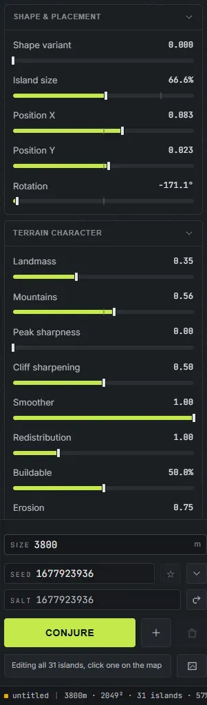
Shape and placement
Section titled “Shape and placement”These set the island’s overall shape, size, and where it sits on the map.
- Shape variant (0 to 1, default 0): morphs the island’s base outline into a different related shape. Use it to roll a different coastline without changing the seed.
- Island size (10% to 120%, default 100%): scales the whole island up or down. Smaller leaves more open ocean, larger fills the map.
- Position X and Position Y (-0.4 to 0.4, default 0): slide the island across the map. Use them to leave room for a second island or to off-center the land.
- Rotation (-180 to 180 degrees, default 0): spins the island in place. Handy for orienting a coastline or a bay a certain way. With several islands selected, or with nothing selected on a multi-island map, it turns the whole group as one piece: the layout swings round the middle of the selection and every island keeps its own shape, exactly as if you had turned the map itself.
Terrain character
Section titled “Terrain character”These control how the land feels: rugged or smooth, mountainous or flat, buildable or wild.
- Landmass (0 to 1, default 0.35): raises or lowers the overall landmass elevation. Higher lifts the terrain up, lower sinks it down.
- Mountains (0 to 1, default 0.50): how prominent the mountains are. Higher raises taller, bolder peaks, lower keeps the terrain low and rolling.
- Peak sharpness (0 to 1, default 0): turns broad, flat summits into alpine ridgelines. It reshapes the top of the land you already have rather than adding height, so the coastline and the amount of buildable ground stay where they were. At 0 nothing changes, which is why a map you generated before this slider existed looks the same today.
- Cliff sharpening (0 to 1, default 0.50): how sharp and steep cliffs are. Higher gives crisp, dramatic cliff faces, lower softens them.
- Smoother (0 to 1, default 1.0): smooths the terrain overall. Raise it to calm noisy terrain, lower it to keep fine detail. This is the one slider on the page that applies to the whole map rather than to the selected island.
- Redistribution (0.5 to 2.5, default 1.0): redistributes the existing landmass. Lower values reduce terrain to create more beach space, higher values raise up the heightmap.
- Buildable (0% to 100%, default 50%): targets how much flat, buildable ground the map has, the kind of ground players put bases on. Raise it for base-friendly maps, lower it for wild, vertical terrain.
- Erosion (0 to 1, default 0.75): weathers the whole map the way Rust’s own erosion does. It barely changes the shape of your land and never moves the coastline; what it mainly does is lay gravel across the ground in blobs and strips, the way a weathered map looks in game. At 0 there is no gravel anywhere; raise it for a rougher, more worn surface.
A few of these sliders, low value on the left, high on the right:
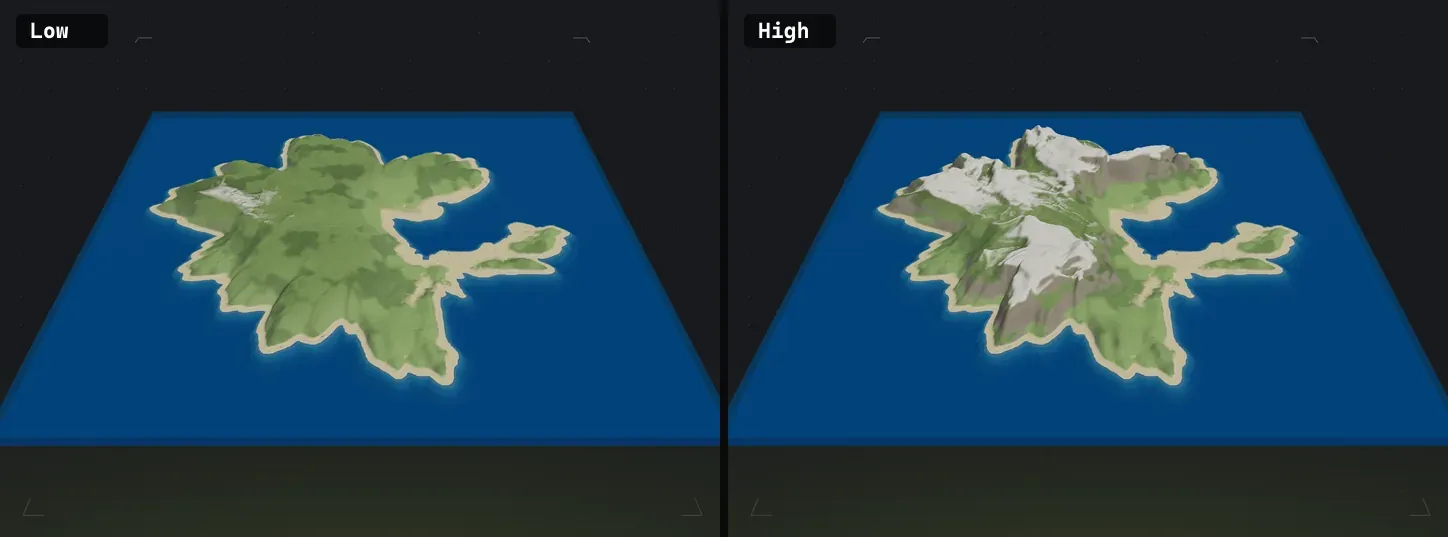 Mountains: low (left) keeps terrain low and rolling, high (right) raises tall peaks. Mountains are chosen randomly based on a few of the highest peaks on each seed.
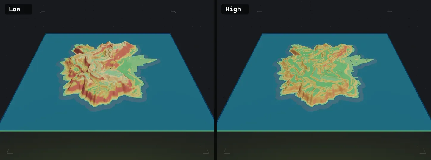 Buildable: low (left) is more naturally wavy, high (right) adds flat, base-friendly ground. Most noticeable around where slopes converge with flat terrain.
Channels
Section titled “Channels”These four are not in the sidebar. Channels is its own tool: the square button to the right of the brush buttons in the toolbar, or press L. The sliders live in its dock, and in the drawing pad. Full page: Channels.
They are listed here because they are sliders and this is the slider reference. A channel is open water cut clean across the whole map, severing every landmass in its path, so the count means the same thing on a one-island map and a thirty-island one.
- Cuts (0 to 16, default 0): how many channels cross the map. Start at 1 or 2 for a map split into a few big pieces, go higher for a broken, waterway-heavy world.
- Variant (0 to 1, default 0): slides the cuts to a different layout without touching your seed, the same way Shape variant rerolls an outline. Use it when you like the map but not where the water runs.
- Width random (0 to 1, default 0): spreads the widths apart. At 0 every cut is the same size; at 1 the spread runs from a hairline creek to nearly double the base width.
- Edge variation (0 to 1, default 1): how ragged the banks are. At 0 a cut has straight sides; the default gives bays, headlands and peninsulas along its length.
Draw cuts opens a pad where you draw channels by hand over your real map. Hand-drawn cuts are added to the ones the sliders roll rather than replacing them, and they stay put while you keep rolling the land underneath. Width random and Variant resize and reshape your drawn cuts as well as the rolled ones.
Channels change the terrain itself, so they carry into the exported map, the in-game view and the worldgen (the water is real ocean, with the shoreline layers to match).
Volcano
Section titled “Volcano”This group is always in the sidebar and stays greyed out until the island you have selected is a Volcano, Crater or Caldera. See volcanoes and craters for what the three styles are.
- Height (default 0.45): how tall the cone stands. Reads out in metres.
- Cone width (default 0.15): how wide its base is, in metres.
- Crater width (default 0.045): the vent’s width. Held under the cone width, so the rim always has cone to sit on.
- Crater depth (0.2 to 2.5, default 1): how deep the vent cuts. The floor cannot sink below sea level, so on a short cone this stops having an effect before the top of the range.
- Crater floor (0.15 to 0.95, default 0.6): how much of the bowl is flat floor rather than inner wall. This is the control that makes a crater a walkable dent instead of a pit.
- Rim ruggedness (0 to 1, default 0.6): how much the rim’s height varies as it goes round. Low is a clean cone, high is a broken ring.
- Lava level (default 55%): how full the vent is. Volcano only, since a crater and a caldera carry no lava.
Five rows apply to a caldera only, and grey out on the other two:
- Water width (0 to 0.95, default 0): how much of the middle is open water.
- Breach (0 to 1, default 0): how wide the ring opens to the sea.
- Breach direction (0 to 355 degrees, default 0): which way the opening faces, as a compass bearing over the map. It holds that bearing when you rotate the island.
- Extra breaks (0 to 6, default 0): more openings, placed at the ring’s own low points rather than at random.
- Break edges (0 to 2, default 1): how ragged the openings are.
These twelve are the one group Slider Defaults in Settings does not cover, because they only mean anything on a cone.
Elevation range
Section titled “Elevation range”These set the height band of your map in meters, on Rust’s 0 to 1000 scale (sea level around 500).
- Ocean floor (100 to 490 m, default 450): how deep the ocean goes. Lower makes deeper water around the island. Avoid raising it near the top or lowering below 400.
- Flat ocean floor (0% to 100%, default 0%): levels the seabed out to the map edge. Normally the ground drops away to the deep ocean floor around the frame of the map; at 100% it is one flat plane from edge to edge instead. Worth knowing before you raise it: that drop is what keeps RustEdit’s train tunnels under the seabed, so above about half, expect tunnels to break through the ocean floor if you run RustEdit’s procedural generation.
- Land floor (500 to 995 m, default 500): the lowest land sits at this height. Raise it to lift the whole landmass. Not useful to change, but here if you find a use for it.
- Land ceiling (505 to 1000 m, default 1000): the tallest peaks cap here. Lower it to flatten the highest terrain, raise it for towering peaks. Not much use for changing unless you want a hard flat cap on terrain peaks.
Coastal stepping
Section titled “Coastal stepping”These shape stepped, terraced coastlines: the cliff-and-bench look Rust coasts often have. There is not much point to changing the defaults on these, but they are useful for island seeds with tall steep slopes that you want to soften a bit near a beach.
- Step intensity (0 to 1, default 0.25): how strong the stepping is. Higher gives pronounced terraces, 0 turns it off.
- Band width (0 to 500 m, default 200): how far inland the stepping reaches from the shore.
- Cliff max rise (5 to 30 m, default 15): the tallest a single coastal cliff step can rise.
- Bench min width (10 to 35 m, default 10): the narrowest a flat bench between cliffs can be. Wider benches give more walkable shelves.
- Bench max angle (0 to 35 degrees, default 9): how steep a bench can tilt before it reads as a cliff instead.
These control the beaches and the underwater shelf around the coast.
- Beach width inland (1 to 150 m, default 20): how far the sand reaches inland from the waterline.
- Outward extension (0 to 150 m, default 9.5): how far the beach reaches outward past the shore. The ground it adds reads as beach, so raising it widens the sand rather than stretching the island’s grass out over the water.
- Underwater shelf (1 to 150 m, default 15): the width of the shallow shelf just below the water.
- Shelf height (default 499.7): how high the underwater shelf sits, just under sea level. Higher keeps the shallows shallow. Its bottom end is wherever you have the Ocean floor slider, so lowering the ocean floor gives this one more room.
- Deep transition (1 to 1000 m, default 125): how gradually the shelf drops off into deep water. Wider gives a gentler slope into the depths.
- Coast coverage (0% to 100%, default 100%): how much of the coastline gets beaches. Lower means sharper drop-offs from beach to ocean floor, higher means more walkable typical Rust beaches.
Surface
Section titled “Surface”The last section in the sidebar is not a slider. Surface sets the selected island’s base ground texture from the eight Rust splats, so an island can read as desert sand, arctic snow, or the default grass before you paint anything on it. It changes the look, never the terrain shape.
The last surface you pick becomes the default for the next island you add. See splat painting for the full picture, and note that once you generate the world the map’s ground texture is derived from the biomes instead.
- Double-click any slider to reset it to its default.
- Save a value you like as your own default in Settings > Slider Defaults.
- These apply per island. When no island is selected, sliders affect all islands at once if you have multiple; when one or more islands are selected, the sliders affect just those. When you combine island seeds, each island also carries its own slider values.